


|
“ “Geodesy for the Layman Home Study” 12 PDHs CER-1885-17 expires 6/12/19 “Geodetic Reference Datums and Local Coordinate Systems Home Study” 5 PDHs CER-1886-17 expires 6/12/19 “Flood Insurance Topics for Land Surveyors Home Study” 6 PDHs CER-1887-17 expires 6/12/19 “FEMA Flood Insurance Studies and Maps Home Study” - 6 PDHs CER-1888-17 expires 6/12/19 “Development and Implementation of NAVD 88 Home Study” 2 PDHs CER-1889-17 expires 6/12/19 “Corpscon Coordinate Conversion Home Study” 3 PDHs CER-1890-17 expires 6/12/19 “Basic Law of Water Boundaries Home Study” 3 PDHs CER-1891-17 expires 6/12/19 |
|
Land Boundaries: Chapter 177 F.S.
Course Description – “Land Boundaries: Chapter 177 F.S.” Course No. 7441 6 HR. Continuing Education Credit in Laws and Rules Category Instructional annotations by: David Melvin, PLS, CFM
“Land Boundaries: Chapter 177 F.S.” is a six hour course that teaches the laws and rules given in Chapter 177 Florida Statues regarding Land Boundaries. David Melvin provides annotated comments as instructional guidance to help in understanding the law.
Course Topics – “Land Boundaries: Chapter 177 F.S.”
· Boundary Survey Requirement · Naming Subdivisions and Streets · Plat Approval Process · Vacation of Plats · Recording Requirements · State Plane Coordinates · Coastal Land Boundaries · Certified Corner Reports
Course Objectives – “Land Boundaries: Chapter 177 F.S.” The objective of “Land Boundaries: Chapter 177 F.S.” is to teach the laws and rules given in Chapter 177 Florida Statues regarding Land Boundaries.
Evaluation Method – “Land Boundaries: Chapter 177 F.S.” A written examination consisting of twenty multiple choice questions will be used to determine if the course objectives have been met. The student must achieve a minimum of 70 percent correct answers in order to receive Land Pro Seminars’ Continuing Education Credit Certification.
Detailed Outline – “Land Boundaries: Chapter 177 F.S.”
PART I: Platting (ss. 177.011-177.151) This portion will cover each sub-section of Part 1 in detail with particular emphasis on sub-section dealing with plats made for recording (ss. 177.091).
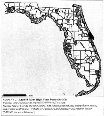
PART II: Coastal Mapping (ss. 177.25-177.40) This portion will be a general overview of Part II with emphases on sub-section dealing with standards for establishment of local tidal datum (ss. 177.38). Procedures and methods for tide observations or the determination of local tidal datum will not be included in this seminar.
PART III: Restoration of Corners (ss. 177.501-177.510) This portion will cover each sub-section of Part III in detail
|